FLIGHT GUIDE: MOLOKAI SEA CLIFFS
On your trip from Kahului airport to Molokai's North Shore, you will encounter whales, rugged coastlines, 1,500 foot waterfalls, rain forests, sail boats, and smooth, North- Easterly trade winds.
Kahului Airport: This busy Class-C airport is the home of Maui Aviators, LLC. Kahului Airport is famous for its gusty trade winds that blow through the valley created by 10,000 foot mount Haleakala to the East and the 6,000 foot West Maui Mountains to the West. You will be sharing the field with numerous tour helicopters, inter-island commuters and jets, heavy jets such as mainland-bound 777s, L-10-11,757,767 and MD-11s, and numerous business jets. Prior to departure, pick up your ATIS on 128.6, call for clearance on 120.6, and switch to Maui Tower when you are ready to depart. General aviation aircraft are not required to contact ground control at any time.
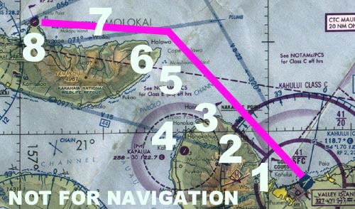
Kahului Airport looking East. Runway 5 (5000') is in the foreground. Runway 2 (7000') intersects Runway 5. The beach in the left foreground is the world-famous Kanaha beach park.
1) Waihee. Your clearance (Maui Clearance 120.6) to depart to the North West will probably be to remain two miles offshore, and maintain 1000 ft. (Remember that in Hawaii our West-bound altitudes are 1,000, 2,000 and 3,000 feet when we are flying below 3,500 ft. East-bound altitudes are 500, 1,500, and 2,500). Dial in 310 on the Kahului Vortac (115.1) and add about 10-15 degrees of cross-wind correction for the strong North-Easterly trade winds. Once airborne, look at the ocean to determine the direction and strength of the wind. The frequency of the white caps gives you an indication of the strength of the wind, which usually blows perpendicular to the direction of the swells. Be sure to notice the dramatic limestone sea cliffs of Waihee ("Why-hay") and the sand dunes of Wailuku ("Why-lou-coo"). Keep your eyes open for tour helicopters coming in and out of the valleys here
2) Kahakuloa ("Kaw-haw-kou-low-ah"). This prominent rock jutting out from the cliffs and protecting a small sheltered bay lies just inside class-c airspace and is a reporting point marked on the charts. Abeam or just past Kahakuloa Maui Approach should tell you to squawk VFR. When they do, set your transponder to 1200 and switch to the CTAF (120.65) for your local reports to Molokai North Shore Traffic.
3) Nakalele ("knock-ah-lay-lay")Point. This is the Northernmost tip of the Island of Maui. On your return leg you should contact Maui Approach on 120.2 and let them know you are in-bound. Be sure to give them your altitude and type of aircraft, and let them know you have the ATIS information.
4) Kahana ("Kaw-haw-nah") and Kapalua ("Kah-paw-lou-ah"). Looking South West as you traverse the Pailolo Channel you will see Kapalua bay, with its two North facing sandy beaches and the Ritz Carlton Hotel, and Honolua bay marine preserve, a favorite among surfers in the Winter. You may want to contact Kapalua Unicom (122.7) to let them know of your intentions and ask them for traffic advisories. However, you will not enter their airspace and should monitor CTAF (120.95) for other aircraft in the area who might not be talking to Kapalua.
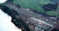
5) Elephant Rock. The Hawaiian name for this little island is "Mokuhooniki". That is why we aviators call it Elephant Rock. Make your first report to Molokai North Shore Traffic here. It should sound something like: "Molokai North Shore Traffic, Cessna 5SP is Elephant Rock, Westbound at 1,000 ft., Molokai North Shore Traffic.")
See the elephant?
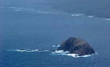
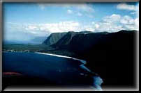
6) Cape Halawa ("Haw-law-vah"). Your next reporting point is the scenic Halawa Valley which marks the end of the road on Molokai's Eastern shore. Note the waterfall in the back of the valley. Keep a sharp lookout for helicopters and cross-country traffic coming from Honolulu.
Cape Halawa.
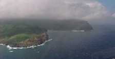
7) Wailau ("why-lah-ow" - 'ow' as in ouch)Valley. This is a deep valley with 2,000 foot walls that harbors a small community of campers on the Eastern side of its beach. Hawaiians once lived here by the thousands, farming taro and fishing the abundant waters of Molokai's North Shore. The sea cliffs here are the highest in the world, plunging over 2,000 feet into the azure depths below. After a good rainfall the coastline is striped with waterfalls and presents one of the most beautiful scenes on Earth.
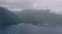
Waila'au Valley.
8) Kalaupapa Peninsula. This historic peninsula jutting out from the cliffs is a county unto itself. The settlement here was established in the late 1800's as a hospital for the treatment of Hansen's disease (Leprosy) patients. You will see Father Damien's historic church and several historic buildings, including a grand old light house as you over-fly the peninsula. Monitor the radio closely for traffic in and out of Kalaupapa field, a small airstrip on the peninsula's North shore, adjacent to the light house, which boasts some of the most severe winds in the state.
Kalaupapa looking East.
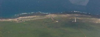
Kalaupapa Field and the lighthouse.
Once you cross the peninsula it's time to reverse course and head back. Be sure to fly at an East-bound altitude of 500, 1,500 or 2,500 feet for VFR separation.