FLIGHT GUIDE: CIRCLE EAST MAUI (HANA - KAUPO - WAILEA)
On your trip from Kahului airport to Hana airport, you will encounter pineapple fields, rugged coastlines, waterfalls, rain forests, movie stars' homes, and smooth, North- Easterly trade winds.
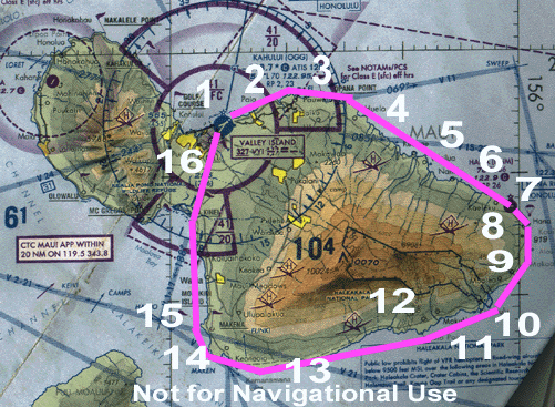
1) Kahului Airport: This busy Class-C airport is the home of Maui Aviators, LLC. Kahului Airport is famous for its gusty trade winds that blow through the valley created by 10,000 foot mount Haleakala to the East and the 6,000 foot West Maui Mountains to the West. You will be sharing the field with numerous tour helicopters, inter-island commuters and jets, heavy jets such as mainland-bound 777s, L-10-11 Tristars, and MD-11s, and numerous business jets. Prior to departure, pick up your ATIS on 128.6, call for clearance on 120.6, and switch to Maui Tower when you are ready to depart. General aviation aircraft are not required or expected to contact ground control at any time.
Kahului Airport looking East. Runway 5 (5000') is in the foreground. Runway 2 (7000') intersects Runway 5. The beach in the left foreground is the world-famous Kanaha beach park.
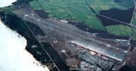
2) Paia ("Pie-ee-ah") town. Departing Kahului Airport, you will turn North and follow the shoreline to Opana Point. On your way you will pass Paia town, a gentrified sugar plantation town that was once the population center of Maui. Paia is home to numerous restaurants and shops, and hosts visitors from all over the world who come to windsurf at nearby beaches and enjoy Paia's bohemian life style. After Paia you will see world famous Hookipa beach park, home of international wind-surfing competitions.
Paia. Mama's Fish House is just in front of the strut at the middle right.
Hookipa beach park
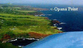
3) Haiku ("Hi-koo") and Opana ("Oh-pah-nah") Point. After Hookipa, the landscape becomes increasing rural. The geometric patterns in the pineapple fields will immediately catch your eye. Scattered among the hills and valleys, you will see numerous homes and several small farms and ranches. Offshore you may see shoals of fish, turtles, dolphins, and whales, all of which can be spotted in Maui's clear-blue near shore waters. The Eastern extremity of the pineapple fields marks Opana point, which is just inside the North-Eastern limit of Kahului Class-C airspace. At this point, Maui Departure will terminate its radar coverage of your flight and you can begin your CTAF position reporting on 120.65. Be sure to ask your instructor for the pronunciations of the local reporting points. Along the coast set your altitude in accordance with Hawaii's local 'hemispheric rule'. East bound VFR flights below 3000 feet generally fly at 500', 1,500', and 2,500'. However, note that most of the tour helicopters and several hapless fixed wing pilots do not abide by this rule and there have been several near-misses, so keep your eyes open.
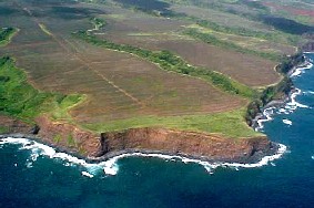
Opana point
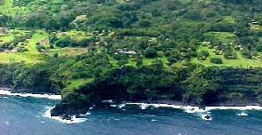
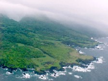
4) Huelo ("hoo-ay-low"), Hole-in-the-Rock, Jurassic Rock. Flying along the coast you will pass several homes, some of which are perched right on the edge of the sea cliffs. Several famous personalities inhabit Maui's North Shore, including Sammy Hagar, George Harrison, Jim Neighbors, and Kris Kristoltsen. Where the houses end and the rain forest begins demarks the end of Huelo. Down on the coastline, you will pass the curious rock formation known as "Hole-in-the-Rock", followed by Jurassic Rock, which you may recognize from the movie of the same name. Thereafter you will pass beautiful Honomanu bay, followed by Keanae peninsula. It is not uncommon to see dolphins in Honomanu bay, but lookout for the overhead power lines and the steeply rising terrain if you venture too far in-shore.
Huelo looking West to Haiku and Opana Point
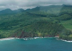
5) Keanae ("K.N.I.") Peninsula. Jutting out from the coastline the prominent Keanae Peninsula is easily spotted. You will see the taro paddies here that have been harvested since pre-contact times. Also note the various water-falls, some of which "fall up" due to the strong trade winds. On a clear day you can see right up into Haleakala crater, where the Apollo astronauts trained for the moon missions.
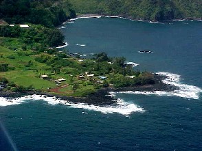
Keanae Peninsula. The baseball field in the middle left might make a nice emergency landing site . . .
6) "Harrison's" and "the Heiau". The next prominent landmark used by the local aviators for a reporting point is the late Beatle George Harrison's house. It looks like a cliff-top golf course and is a good place to begin your descent into Hana ("hah-nah"), which is clearly visible by now. Just past Harrison's you will see a large black stone platform that stands out from the surrounding rain forest. This is a sacred ancient Hawaiian Heiau ("Hey-Ow!") and is a good line-up for your downwind when in left traffic for Hana's runway 8.
George Harrison's golf course-like estate.
7) Hana airport. Hana airport is an uncontrolled airport that services isolated Hana town. Many tour helicopters stop in Hana for lunch, or to drop off and pick up guests, so keep your eyes and ears open. Also, there is a powered hang glider based out of Hana conducting introductory lessons. He does have a radio on board, but can make some surprising unannounced appearances. Usually the winds favor runway 8, but be sure to over-fly the field at about 1,500' to observe the winds on the ground, and to make sure there are no cows, wild boars, or lawn mowers on the field. Pattern altitude is 800' and runway 8 uses left traffic.
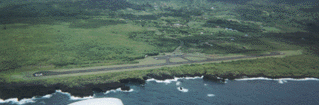
Hana Airport, looking South West (on down-wind to RWY 8)
Hana airport's luxurious ground facilities include a pay phone, a drinking fountain, and restrooms. No fuel is available. Rental cars and taxis (by phone) are available.
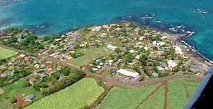
8) Hana ("Hah-nah") Bay. Proceeding south from Hana Airport you will see the sleepy little town of Hana on the slopes overlooking tranquil Hana bay. It takes about 2-3 hours to get to Hana by car from Kahului. You have made it in 20 minutes. In Hana you will see the Hotel Hana Maui, Hana Ranch, and several historical and ancient Hawaiian sites.
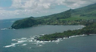
Looking East over Hana Airport at Hana town.
9) Hamoa ("Ha-mow-ah") Beach. Nestled behind the ancient cinder cone called Makaalae by the Hawaiians is the tiny surfing beach of Hamoa. Nearby you will see the old church where Charles Lindbergh is buried. Look up the slopes and you'll probably catch a glimpse of the several water falls that cascade down Haleakala's Eastern slopes.
10) Ohe'o ("Oh-hay-oh") Gulch. Commonly and erroneously known as "Seven Sacred Pools", Kipahulu stream, with its numerous water falls and swimming holes contains dozens of pools, none of which were ever sacred. You will see travelers worn-out from the half-day long drive resting their weary bones beside the waters of this Federal park which also hosts a drive-up camp site.
Oheo gulch and federal campground.
11) Kaupo ("Cow-poh") settlement. Once a substantial population center, Kaupo is now one of the most remote areas in the state. There are several old churches to be seen along the coastline, some over 150 years old. Other evidence of the once abundant population can be seen in the stone formations that mark the ancient villages and home sites all along this dry coastline. Also note how the Eastern slopes of Mount Haleakala block the progression of the clouds, robbing the air of its moisture and making Kaupo a virtual desert.
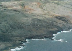
12) Mount Haleakala ("Hah-lay-ah-kah-law"). Rising from sea level to 10,025 feet in just four horizontal miles, the Southern slopes of this Mountain present a dramatic and colorful landscape. Looking up from Kaupo, you can just see into Haleakala crater, where the astronauts once trained. Follow the coastline here and note the Hawaiian Ruins, the ancient "King's highway". Be wary of the turbulence. It's not unusual to have 30 to 40 knot winds along this shore, as the channel between Maui and the island of Hawaii is bordered by a 10,000 foot mountain on the North, and a 14,000 foot mountain on the South.
13) La Pereuse Bay and the Lava Flows. The South-Western slope of Haleakala is the site of the last volcanic eruption on Maui, approximately 200 years ago. The valley winds meet the channel winds off La Pereuse bay, so expect some turbulence here. The crystal-clear waters of the La Pereuse bay marine reserve are a favorite snorkel and dive destination, and it is not unusual to spot dolphins and turtles here. As you come around this point, Kahului radar should be able to pick you up, if you are above 1,500 feet, so go ahead and get your ATIS (128.6) and give Maui Approach (119.5) a call to let them know you are in-bound from Makena.
LaPereuse bay.
14) Makena ("Mah-ken-ah") Cinder Cone. This prominent hill next to the half-mile long Makena beach cradles a small nudist beach along its Western shoreline. This is a reporting point for entering Kahului Class-C airspace. If you plan to transition to Lahaina from here, it is a good idea to go ahead and call Maui Approach on 119.5 to let them know of your intentions, as they can give you traffic advisories and keep you out of harm's way.
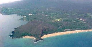
Makena cindercone. The small beach in the foreground is popular with nudists. (A good place to practice eights-on-pylons?)
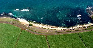
15) Molokini ("Mow-low-kee-nee") Crater. Just offshore of Makena is the world-famous snorkel and dive destination, Molokini Crater. This tiny crescent island is over-run with hundreds of cavorting snorkelers every day. It is much more comfortably viewed from the air.
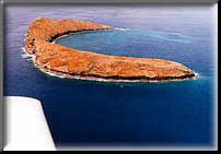
Molokini island.
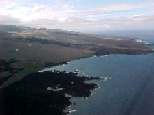
16) Kihei ("Key-hay") and the isthmus. Continuing North from Makena you will pass Wailea resort with its numerous golf-courses and five star resorts. North of Kihei is the isthmus between the West Maui Mountains and Mount Haleakala commonly called "the Valley." On the Southern shore of the isthmus is the Kealia nature preserve which is comprised of two large ponds adjacent to Sugar Beach just North of Kihei. To return to the airport from here you could track in-bound on the Kahului Vortac, 115.1, or follow the highway to the Puunene Sugar Mill. The highway is clearly recognizable as a dark band of trees proceeding Northward through the sugar fields. Be sure to note the remnants of the World War II military bases scattered among the fields here. For your final approach, line up over the Sugar Mill at 800', just to the East (right) of the smoke stacks and you will be on the glide slope. In fact, there is an official approach procedure called the "Smoke Stack Visual Runway 2" that uses this mill.
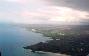
Looking North over Makena at Wailea and Kihei.
Top